

The island of Kythira covers an area of 284 km². The island is 29 km long and 18 km wide. The geotectonic units that make up the island of Kythira are found in Macedonia, Thessaly, Central Greece, the Peloponnese, and Crete. The island’s topography is mountainous, with steep coastlines and a basin in the eastern part of the island. Kythira belongs to the Alpine system and, more specifically, to the southern branch of the Tethys orogenic system (Papanikolaou, 1986). The southern branch of the Tethys orogenic system includes the Apennines, the Southern Alps, the Dinarides, the Taurides, the Iranides, and subsequently sections of other mountain ranges extending to the Himalayas. The geological basement of Kythira consists of formations belonging to the following geotectonic units: the Arna Unit, the Tripoli Unit, and the Pindus Unit, while the eastern part of the island is covered by Neogene deposits.
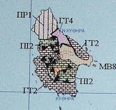
More specifically, the sections that appear on the island of Kythira are described below:
PR1: Peloponnese-Crete Phyllitic Series [Arnas Unit] (Permian age, 280,000,000 to 200,000,000 years ago). It consists of metamorphic rocks (quartzite and marly schist) located in the northern part of the island. Several quartzite intrusions are also observed, in the form of lenses or horizons. It occurs on the western side of Kythira and forms the mountains of «Mermigari,» «Leskas,» »Myrtidion,« »Ag. Elessa,« and »Kastro Chora.”.
PI2: Pelagic limestones [Pindos Unit] (Upper Cretaceous, 100,000,000 to 65,000,000 years ago). It occurs in the central and southeastern parts of the island.
GT4: Dolomites, mainly dolomitic limestones [Tripoli Unit] (Middle Triassic–Jurassic, 210,000,000 to 141,000,000 years ago)
GT2: Limestones of the Tripoli Unit (Paleocene–Middle Eocene, 65,000,000 to 55,000,000 years). The Tripoli Formation occurs mainly in the northeastern and western parts of the island. The island’s two mountain ranges are composed of the Tripoli Formation.
MB8: Marine and brackish deposits: conglomerates, sands, sandstones, marls (Upper Miocene–Pliocene, 10 to 2 million years ago). They cover the northeastern part of Kythira, which lies between the two mountain ranges, as well as other areas in the southern and northern parts of the island.
Written by Dr. Dimitrios Alexakis
Environmental Geologist and Geochemist, Research Associate at the University of Athens—Lecturer (Presidential Decree 407/80)