Forest fires in Greece have a particularly significant impact on the composition of the atmosphere and air quality. As a detailed analysis of the AtmoHub coordinated by the team NOA – ReACT of the IADET/National Observatory of Athens, even though carbon dioxide (CO2) are generally much smaller than anthropogenic emissions on a percentage basis (<5% of total annual national emissions), during extreme wildfires, they increase dramatically.
In their analysis for the Athens-Macedonian News Agency, the AtmoHub research team points out that in recent years, Greece has been experiencing increasingly frequent and intense episodes of widespread wildfires, exacerbated by the effects of climate change. With nearly a month remaining before the end of the fire season, researchers emphasize that it is leaving behind severe damage to forest and agricultural land, livestock farms, settlements, as well as a negative impact on atmospheric conditions.
«In Greece, as of August 19, 2025, approximately 470,000 stremmata of burned land were recorded, placing the year 2025 in fifth place in the ranking of total annual burned areas over the past two decades. In the summer of 2025, the areas affected included, among others, Ierapetra, Chios, Oropos, Rafina, Palaia Fokaia, Keratea, Feneos in Corinthia, Plytra in Laconia, Kythira, Vonitsa, Achaea, Arta, Zakynthos, and Vourvourou, with the total area of land burned in these regions estimated at approximately 260,000 stremmata.
In the European Union in particular, 2025 saw a record number of forest fires, with more than 10 million stremmata of land burned. Spain, Cyprus, Germany, and Slovakia surpassed every previous annual record for burned areas over the past 20 years, with Portugal and Spain remaining the hardest-hit EU countries for the year 2025, with more than 4 million stremmata reduced to ashes,» the team emphasizes.
In addition to the above, there is recent data released by the Copernicus Atmosphere Monitoring Service (Copernicus Atmosphere Monitoring Service / CAMS), according to which carbon dioxide (CO2) from this year’s wildfires in Europe reached their highest levels in the past 23 years—that is, since systematic recording began.
With regard to Greece in 2025, as the AtmoHub team notes, from the beginning of the year through the end of August, black carbon emissions in our country reached 685 metric tons, in line with the average for the years 2003–2024.
The following is an analysis by members of the AtmoHub scientific team, specifically Vasilis Amoiridis, Anna Kampouri, Marios Mermiagas, Thanos Kourantos, Konstantinos Michailidis, Vasilis Spyrakos, and Olga Papadopoulou.
Effects of Forest Fires on the Atmosphere
The team, in explaining in detail the effects of wildfires on the atmosphere, emphasizes that they degrade air quality, with significant implications for public health, especially when smoke drifts over populated areas. «Two of the most significant gaseous pollutants resulting from forest fire emissions that negatively affect human health are black carbon and carbon monoxide (CO). Black carbon is a component of particulate matter with a diameter of less than 2.5 micrometers (PM2.5) emitted by wildfires and the incomplete combustion of materials. Because these particles are so fine, black carbon can penetrate deep into the lungs and the circulatory system, causing or exacerbating respiratory and cardiovascular diseases. »Carbon monoxide is also a gaseous pollutant, which in high concentrations becomes particularly toxic and harmful to human health,” he notes, adding that another gaseous pollutant emitted during a wildfire is carbon dioxide (CO2).
«Carbon dioxide belongs to a very important category of gaseous pollutants: greenhouse gases. Greenhouse gases have the property of absorbing heat emitted as radiation from the surface of our planet and re-emitting it in all directions, thereby disrupting the radiation energy balance and causing the planet’s temperature to rise. »Carbon dioxide can remain in the Earth’s atmosphere for over a hundred years after it is emitted, significantly contributing to global warming and climate change," the team explains.
In the case of extreme fires of great intensity and extent (megafires), as he points out, smoke can penetrate from the troposphere (the layer of the Earth’s atmosphere where weather phenomena occur) into the stratosphere, even at altitudes above 10 kilometers (the altitudes at which jet aircraft fly). «There, the smoke extends its lifespan, remaining in the stratosphere for a period ranging from several months to a year, affecting the stratospheric ozone layer that protects us from harmful ultraviolet solar radiation. Furthermore, soot particles in the stratosphere act as scatterers of incoming solar radiation, reflecting sunlight back into space—thereby increasing the planet’s albedo (reflectivity)—and reducing the amount of solar radiation reaching the Earth’s surface. This process can lead to a decrease in temperature, similar to the effect of emissions from volcanic eruptions, such as the 1991 eruption of Mount Pinatubo, which led to a 0.5 °C drop in global temperatures for two years,» the researchers note.
Forest Fire Emissions in Greece
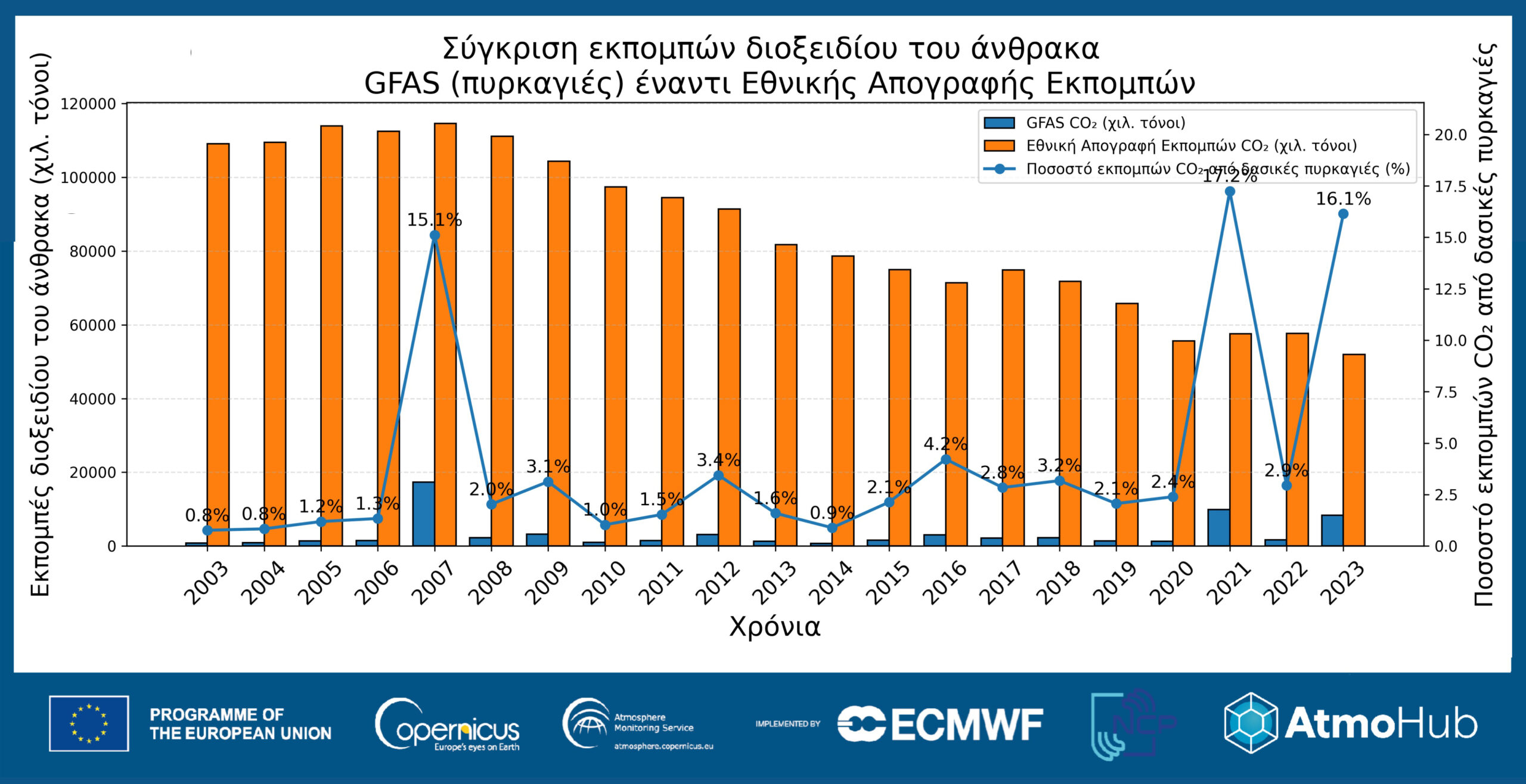
Specifically, with regard to emissions from wildfires in Greece, a graph (Graph 1*) shows the total annual carbon dioxide (CO₂) from wildfires in Greece, using data from the Global Fire Assimilation System (GFAS) of CAMS (blue bars), as well as the country’s annual anthropogenic carbon dioxide emissions, as part of the national carbon dioxide emissions inventory* (orange bars; emissions from Land Use, Land-Use Change, and Forestry—LULUCF—are excluded).
«The percentage comparison (blue line) shows that while emissions from wildfires are generally much smaller than anthropogenic emissions (<5% of total annual national emissions), during extreme wildfires they increase dramatically. In 2007, carbon dioxide emissions from wildfires amounted to approximately 1.73 million metric tons, accounting for 15% of total national emissions. A similar pattern was observed in 2021 (~9.9 million metric tons, ~17%) and 2023 (~8.4 million metric tons, ~16%), when wildfires temporarily became one of the most significant contributors to the country’s total carbon footprint,» the AtmoHub team emphasizes.
At the same time, another graph (Graph 2*) illustrates the correlation between the annual area burned (orange line—right vertical axis) and carbon dioxide (CO2) emissions from wildfires (blue bars—vertical axis on the left) for the period 2006–2025. «The years with the largest burned areas appear to be associated with higher emission levels, a fact that reflects the decisive role of fuel. However, this is not always the case, as in some years the intensity and characteristics of the fire can lead to disproportionately high emissions relative to the area burned,» notes the AtmoHub team.
As explained, three years in Greece stand out as extreme cases:
In 2007, when extensive forest areas across the country were burned and the highest emissions on record for that period were recorded.
In 2021, during the major wildfires in Euboea and other regions, emissions reached extremely high levels due to the vast area that was burned.
In 2023, the wildfire in Evros—the largest in European history—caused massive carbon dioxide emissions, underscoring the significance of individual, extreme events.
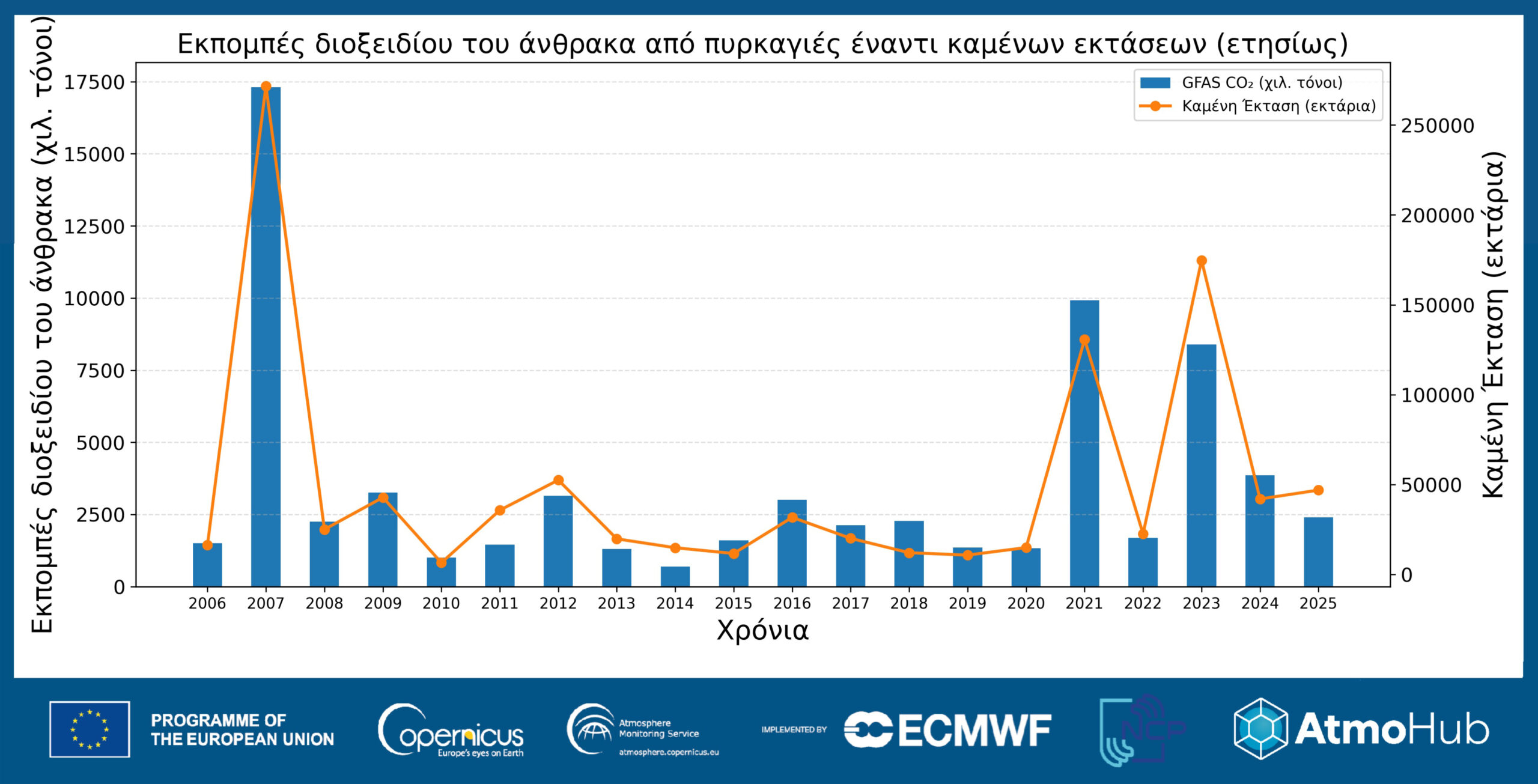
«This analysis shows that, while the area burned is a key factor in the volume of emissions, the intensity of the fire, the type of fuel, and local conditions can significantly amplify or mitigate the overall impact on the carbon balance,» the researchers note in a statement to the Athens-Macedonian News Agency (ANA-MPA).
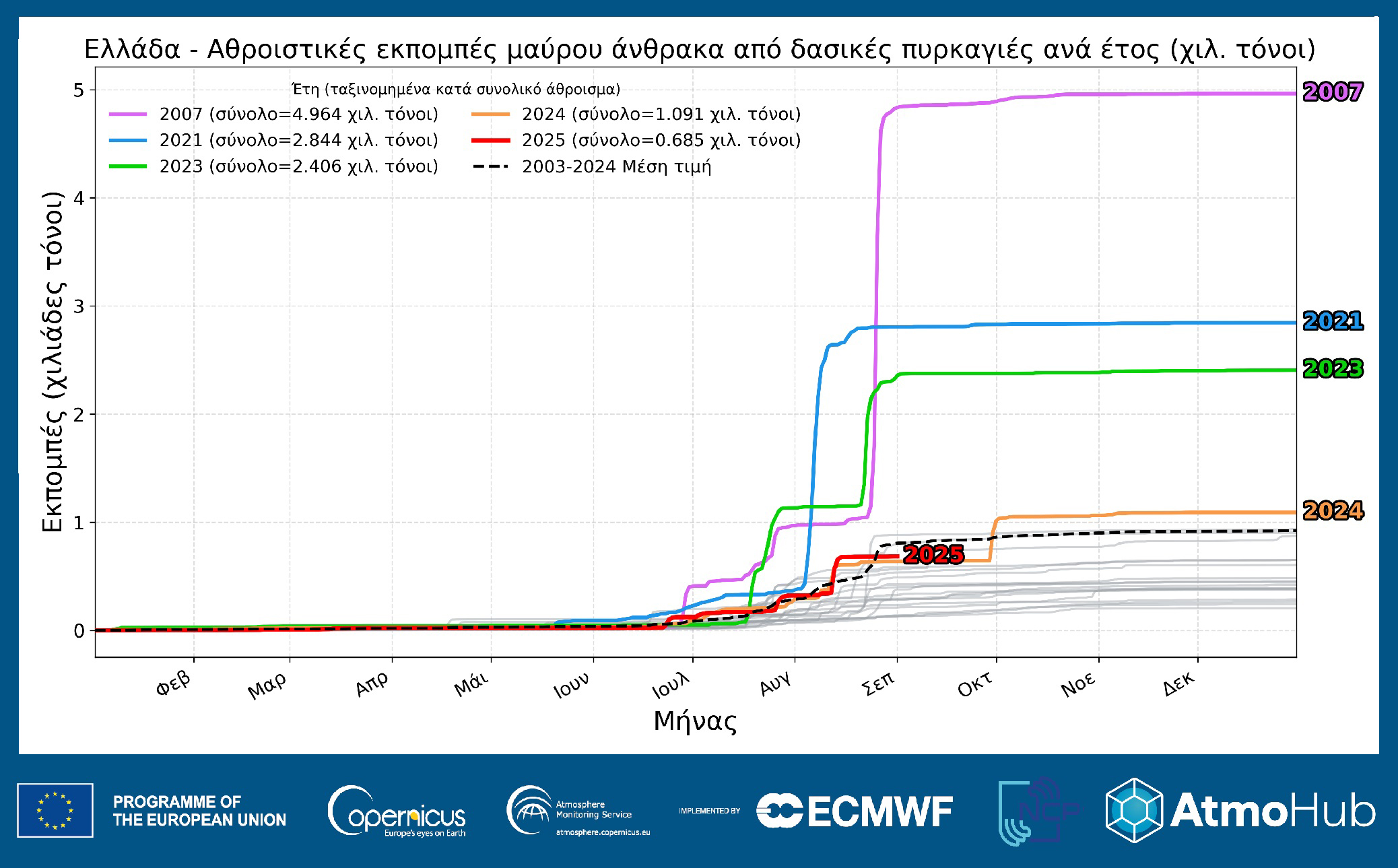
Finally, another graph (Graph 3*) shows, in different colors, the total black carbon emissions from wildfires in Greece by year, based on data from the Global Fire Assimilation System (Global Fire Assimilation System – GFAS) and the Copernicus Atmosphere Monitoring Service (CAMS). As shown, these curves exhibit a slight increase in May–June and typically sharp increases in July–September —often due to intense wildfire episodes in August.
«For the year 2025 (red line), from the beginning of the year through the end of August, black carbon emissions in Greece reached 685 metric tons, in line with the average for the years 2003–2024 (black dashed line). The top three years with the highest black carbon emissions in our country are 2007 (~4,960 metric tons), 2021 (~2,844 metric tons), and 2023 (~2,406 metric tons),» the team emphasizes.
Satellite and Ground-Based Remote Sensing for Monitoring Wildfires in Greece
As the researchers point out, the Observatory of Geosciences and Climate Change plays an important role in monitoring smoke transport from wildfires (PAGE), of the National Observatory of Athens (NOA) in Antikythera. The station, using the advanced PollyXT LIDAR system (which is part of international networks EARLINET and PollyNet), records with high resolution the vertical distribution of airborne particles from forest fires that are carried by the wind into the atmosphere. «These measurements are important because they reveal the type, size, and shape of the airborne particles that make up the smoke, helping to better assess air quality and the impacts on human health. »The PAGGAIA observatory is a key tool for understanding the evolution of smoke transport phenomena, as well as for strengthening civil protection strategies,” they note.
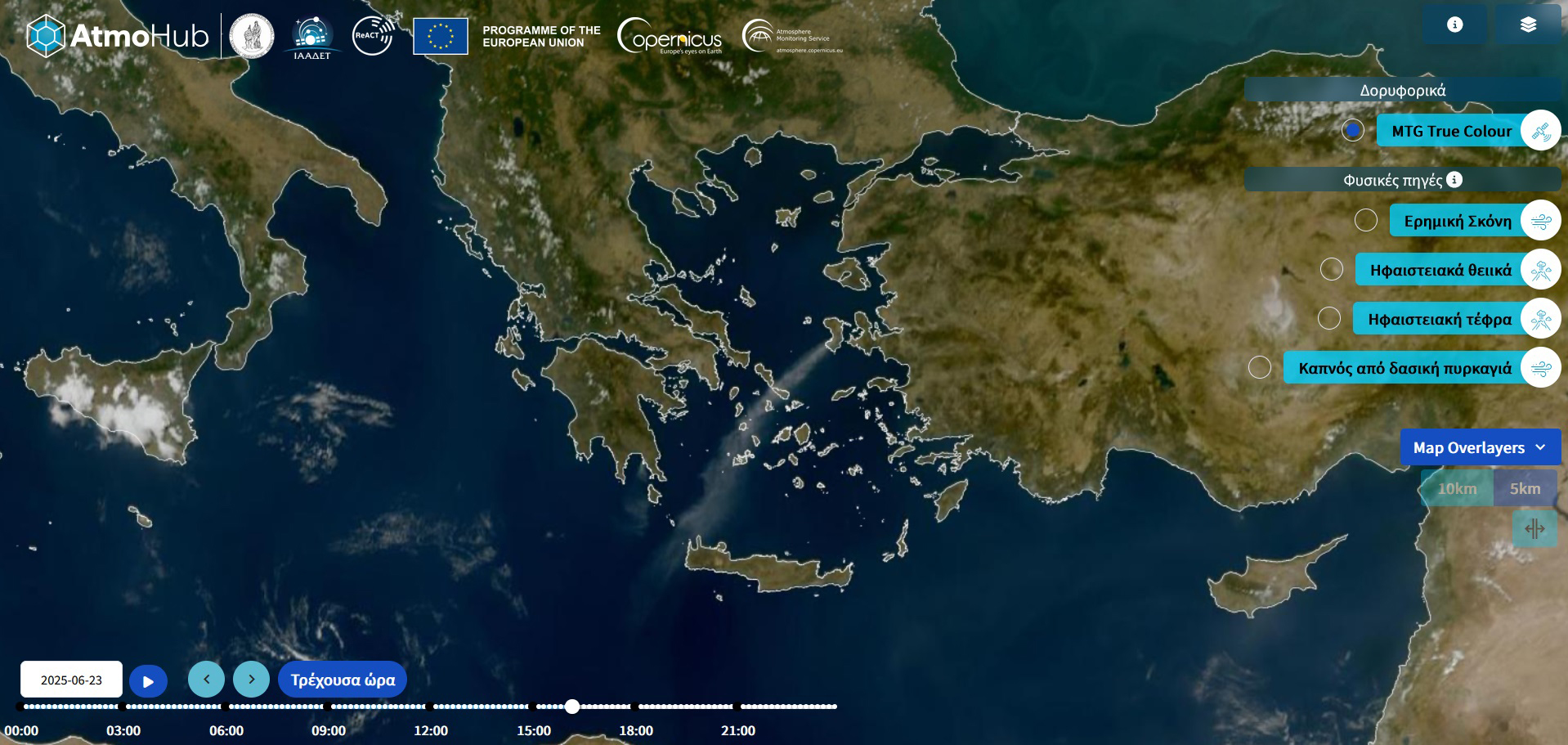
Satellite observations, image analysis techniques, and modern monitoring methods also play a crucial role in the early detection, mapping the spread, and assessing the impacts of wildfires on the natural and human-made environments. For example, in the fire on Chios on June 23, 2025, as captured by satellite, an extensive plume (formation, plume) of smoke originating from the island and moving southwest, covering a large portion of the Aegean Sea as far as Crete (Figure 4*). This image, as the scientific team emphasizes, captures with striking clarity the spatial dimension of the phenomenon, highlighting the role of atmospheric conditions —specifically strong northerly winds—in the rapid transport of smoke and airborne particles hundreds of kilometers away from their source.
Early Warning Service for Smoke from Forest Fires
Finally, as announced by the AtmoHub team, the Early Warning System for smoke from wildfires will begin operations in 2026. «Using data from the CAMS service, EUMETSAT’s Meteosat Second Generation (MSG) satellite, and the FLEXPART dispersion forecast model, this service aims to provide the public and the government with timely and accurate information regarding smoke transport events and their health impacts,» the researchers emphasize in a statement to the Athens-Macedonian News Agency (ANA-MPA).
Ioanna Kardara